Main Road Corridor Segment C
Public Information Meeting
May 14, 2024
Charleston County welcomes you to the third public information meeting for Main Road Corridor, Segment C: Bohicket Road from Maybank Highway to Betsy Kerrison Parkway. The purpose of this meeting is to present the Recommended Preferred Alternative for this project.
The project team invites you to review the Recommended Preferred Alternative presented below, review the process of how the County narrowed down the design alternatives, and provide feedback on the Recommended Preferred Alternative.
Please submit comments by filling out the form at the bottom of this page, or by clicking the Contact tab at the top of this page. Your comments will help the project team refine the Recommended Preferred Alternative.
How did we get here?
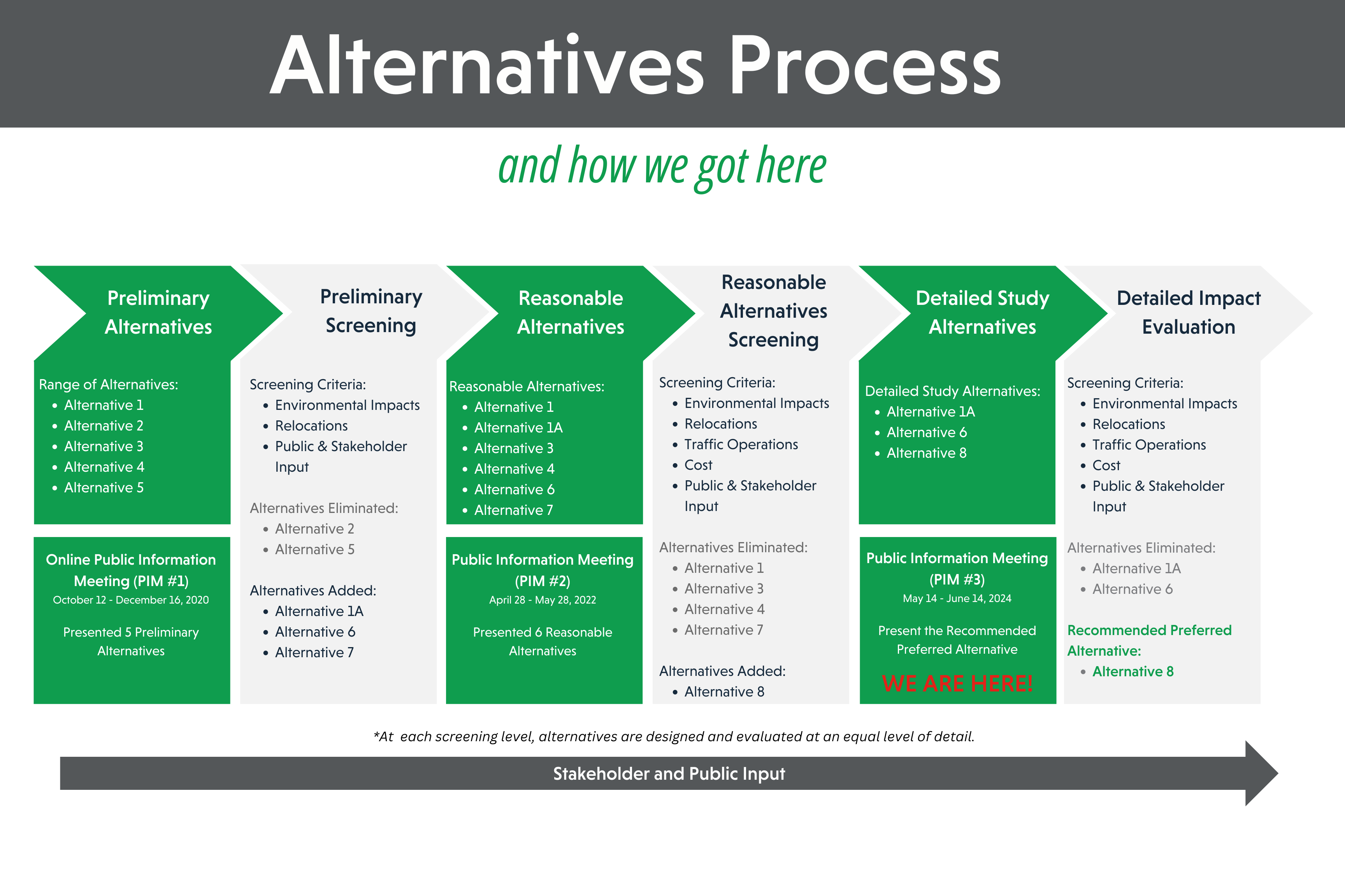
Charleston County initially identified five preliminary alternatives that met the purpose and need of the project, including widening existing roadways and constructing new roadways. These five alternatives were presented at an online public information meeting in October-December 2020 (due to COVID-19 public gathering restrictions) for review and comment. During the comment period the public showed a desire for an in-person meeting and Charleston County agreed to hold a second meeting once COVID-19 restrictions were lifted. During this period, public involvement was ongoing and three additional alternatives were identified (Alternatives 1a, 6, and 7) and Alternative 2 and Alternative 5 were eliminated from further consideration due to extensive impacts. Six reasonable alternatives were presented for public comment at a second public meeting, held in person on April 28 and May 12, 2022, and online for a 30-day comment period. All six alternatives (Alternatives 1, 1a, 3, 4, 6, and 7) met the purpose and need of the project and have varying impacts to natural and human environments.
After collecting and analyzing public input and discussions with regulatory agencies and stakeholders, the project team continued to refine the alternatives. Four alternatives (Alternatives 1, 3, 4, and 7) were eliminated due to extensive impacts, two alternatives (Alternative 1a and Alternative 6) were carried forward and further refined, and one new design alternative (Alternative 8) was identified. Alternative 8 was developed as a combination of Alternative 1a and Alternative 6 based on additional analysis and stakeholder feedback. After further analysis, Alternative 8 was selected as the Recommended Preferred Alternative.
To view Alternative 1a and Alternative 6, click the links below:
Alternative 1a OverallAlternative 1a
Alternative 6 Overall (note this alternative has been modified since PIM #2)
Alternative 6 (note this alternative has been modified since PIM #2)
What is the Recommended Preferred Alternative?
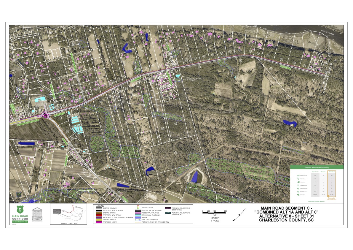
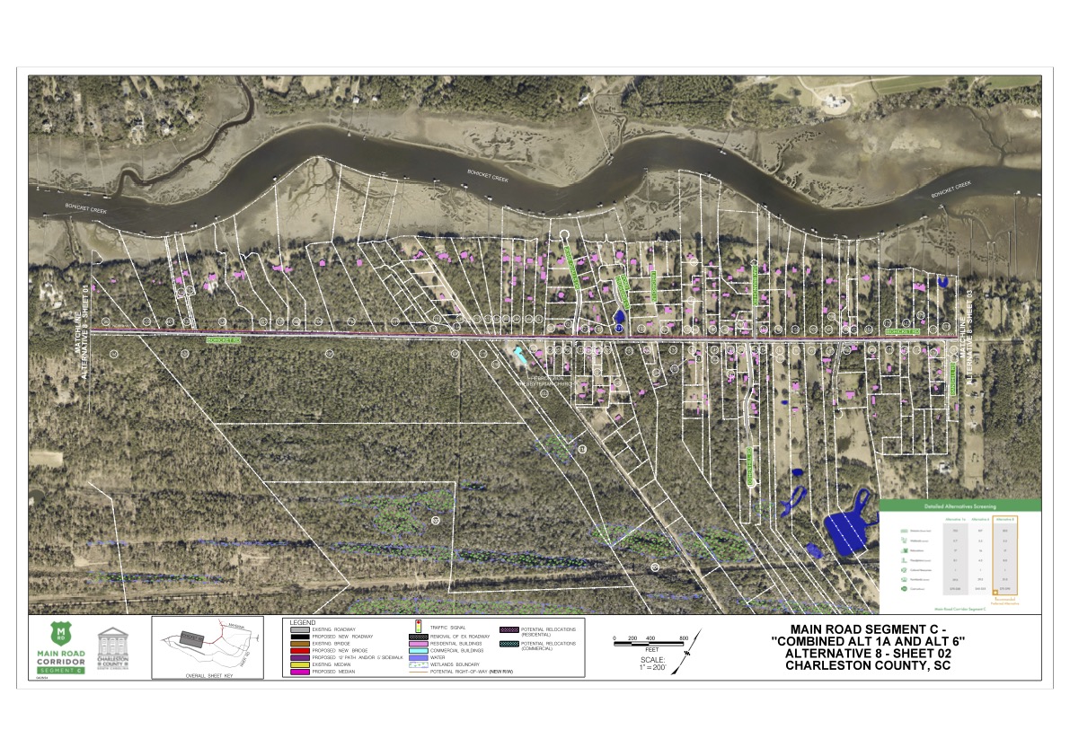
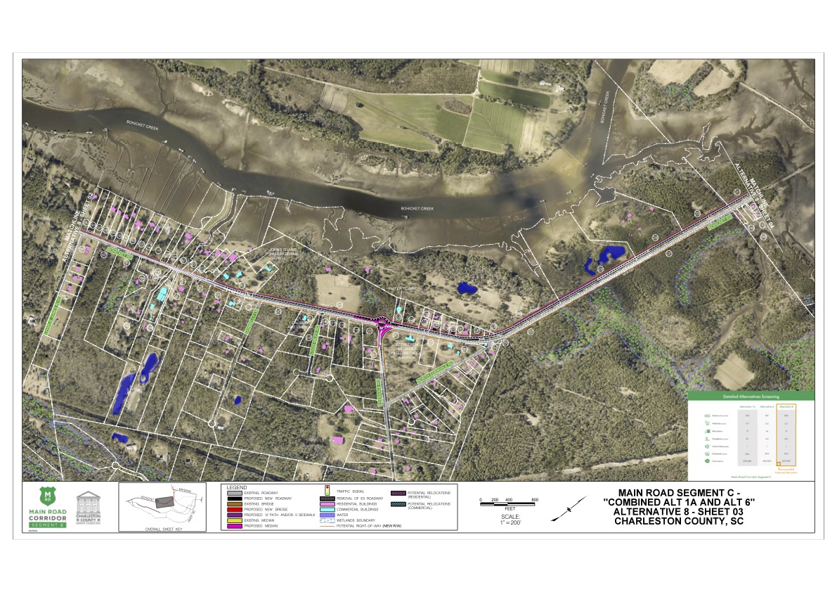
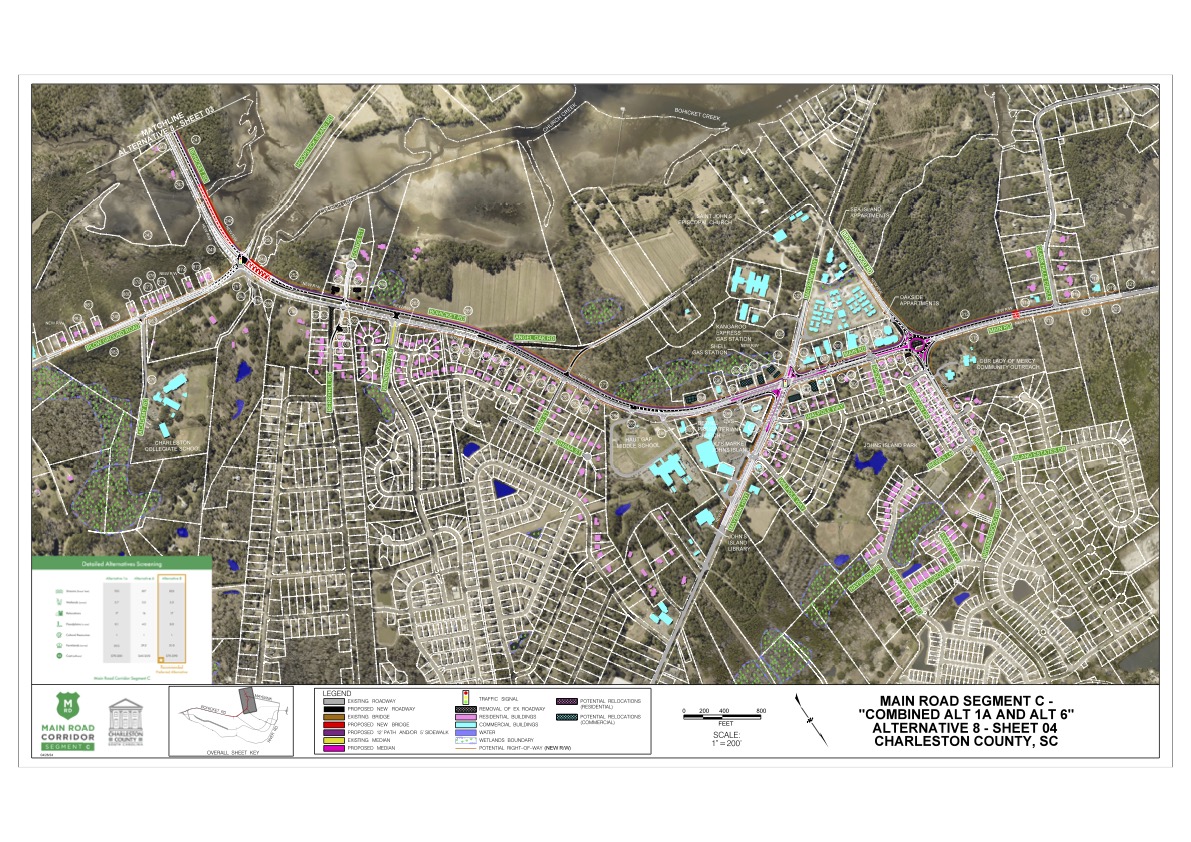
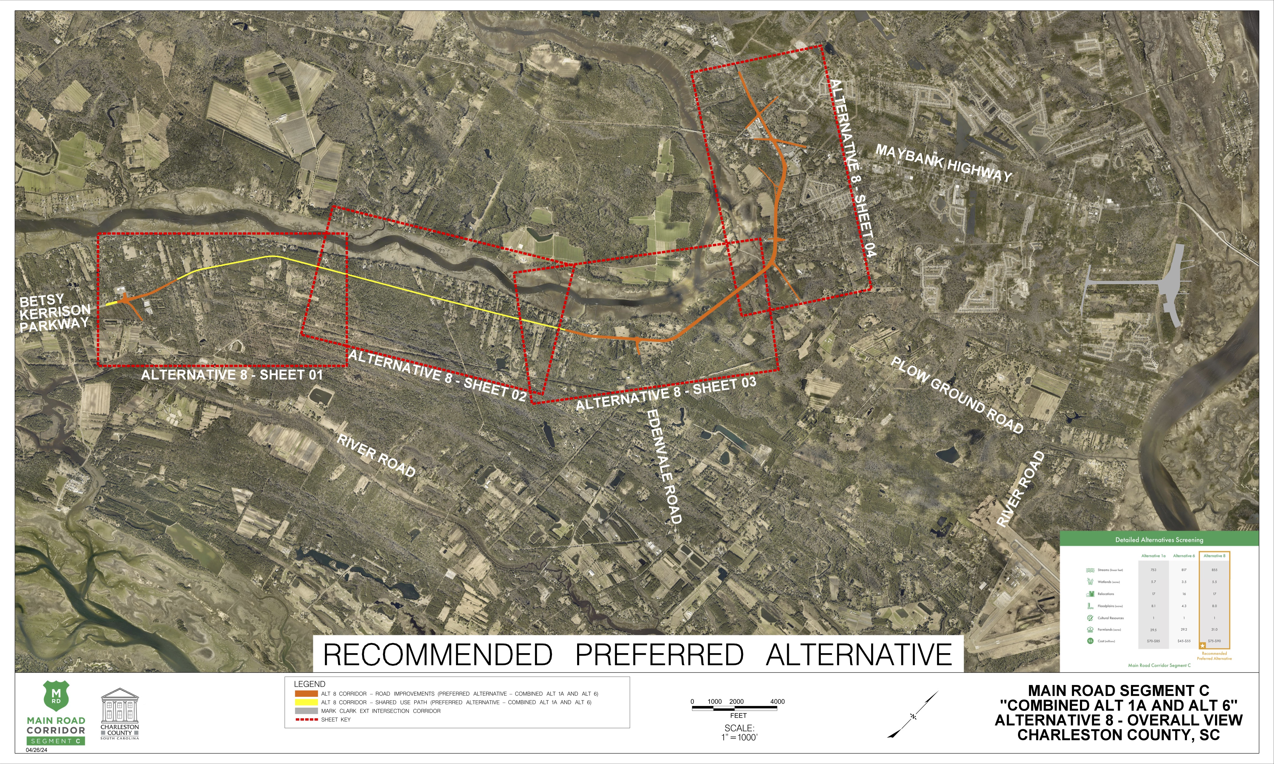
Charleston County proposes to move forward with Alternative 8 as the Recommended Preferred Alternative. Alternative 8 is a combination of Alternative 1a and modified Alternative 6. The proposed improvements associated with the Recommended Preferred Alternative would include:
-
Widening Bohicket Road from about a quarter mile west of Edenvale Road to a half mile west of Brownswood Road with:
- sections of a 4-lane roadway with a center turn lane
- sections of a 4-lane divided roadway to minimize impacts to grand trees
- sections of a 5-lane roadway with a center turn lane to minimize impacts to residences in the more densely populated areas of Bohicket Road
- Adding a multiuse path along the entire corridor, from the intersection of River Road and Betsy Kerrision Parkway to Clark Hills Circle
- Intersection improvements along Bohicket Road at:
- Edenvale Road, Plowground Road, Brownswood Road, Maybank Highway, and at River Road and Betsy Kerrison Parkway
- Roundabouts at the Edenvale, Brownwood, and River Road intersections
Alternative 8 has the second fewest wetland impacts, and the second fewest floodplain impacts. It has the same amount of residential relocations as Alternatives 1A and 6 (fourth lowest of all) and the same number of commercial impacts as Alternative 1A. Alternative 8 performed the best or tied for the best overall at relieving traffic congestion along the corridor, and had the second lowest estimated cost to construct.
What happens next?
Once the public comment period has ended, the design team will continue to develop and refine the Recommended Preferred Alternative. This will help define the exact impacts the design will have on the environment and existing properties. Once this process is complete, Charleston County will submit a permit application for impacts to waters of the U.S. (wetlands and streams) to the U.S. Army Corps of Engineers (USACE). USACE will ultimately permit the least environmentally damaging practicable alternative (LEDPA). USACE must agree that Charleston County’s Recommended Preferred Alternative is the LEDPA before issuing the required permits. Once the County has received all required permits, and all necessary rights-of-way have been acquired, the project can proceed to construction.
How did the County select the Recommended Preferred Alternative?
Each design alternative went through a multi-tier screening process to evaluate estimated impacts and determine how it met the project’s purpose and need. The final step in the screening process evaluated:
- impacts to environmental resources such as streams and wetlands
- ability to accommodate anticipated future traffic volumes (relieve traffic congestion)
- potential property relocation impacts for both residential and commercial properties
- overall project cost
Project Purpose
The purpose of the project is to enhance traffic operations by reducing existing traffic congestion along the Main Road corridor while accommodating future traffic needs.
The primary purpose of the project is to:
- Reduce congestion.
- Increase capacity on Main Road/Bohicket Road from Maybank Highway to Betsy Kerrison Parkway.
The secondary purpose of the project is to:
Provide opportunities for bicyclists and pedestrians to safely travel throughout the project area.
Project Background
Charleston County identified funding to improve Main Road in the 2016 Transportation Sales Tax ordinance. At that time, the ordinance listed the project as the US 17 at Main Road flyover and widening Main Road from Bees Ferry Road to Betsy Kerrison Parkway. In an effort to expedite improvements, the County has separated the project into three segments: Segment A, Segment B, and Segment C.
Segment C begins at the intersection of Bohicket Road and Maybank Highway and extends to Betsy Kerrison Parkway. The project team studied several options for the segment, including widening River Road, widening Bohicket Road, and constructing a new road across the island.
A video is being shown
Project Development Process
All federally aided projects and/or projects with the need for federal permitting must comply and adhere to the National Environmental Policy Act (NEPA). The NEPA process often takes three (3) to eight (8) years to complete, and is initiated when the federal agency becomes engaged, which for this project begins with submission of the Clean Water Act (CWA) permit application to the U.S. Army Corps of Engineers (USACE). The NEPA process requires the following to complete:
- Public input throughout
- Technical studies (18)
- Development of alternatives
- Analyze alternatives
- Development of a Preferred Alternative
- Preparation of a draft environmental assessment
- Revision of the preferred alternative
- US Army Corps of Engineers decision
Current Status
Based on analysis and public and stakeholder input since the April-May 2022 public meetings, Charleston County has selected the Recommended Preferred Alternative. The project team now needs your input on the Recommended Preferred Alternative.
Next Steps
Once the public comment period has ended, the design team will review and respond to all comments received. The project team will then conduct a detailed impact evaluation and will use your input to refine the Preferred Alternative and produce preliminary design plans. Charleston County will then submit a permit application to USACE for the proposed improvements.


Alternative 8
Recommended Preferred Alternative ($75-$90 M)
Alternative 8 KMZ
This KMZ file works in the program Google Earth, and will allow you to view the entire alternative. The KMZ file is a more interactive option to viewing the alternatives. However, this option will not show the matrix comparing the alternatives or a legend.
DownloadWetland Impacts
Land permanently or seasonally covered with water is called a wetland. Wetlands are considered “waters of the United States” and are regulated under the Clean Water Act. The project team must identify all wetlands within the project area and avoid impacting them if possible. If an alternative meets the purpose of the project but cannot avoid impacts to a wetland, the County is required to minimize and mitigate impacts.
5.5 acres
Stream Impacts
Streams are considered “waters of the United States” and are regulated under the Clean Water Act. The project team must identify all streams within the project area and avoid them if possible. If an alternative meets the purpose of the project but cannot avoid impacts to streams, the County is required to minimize and mitigate impacts.
855 linear feet
Potential Relocations
These are properties that may require relocation of the residence or business in order to construct the project. The project team must identify all potential property relocations within the project area and avoid them if possible. If an alternative meets the purpose of the project but cannot avoid property relocations, the County is required to follow the United States Uniform Relocation Assistance and Real Property Acquisition Policies Act of 1970, the South Carolina Eminent Domain Procedure Act, and SCDOT’s Right of Way Manuals.
17
Floodplain Impacts
Floodplains are areas next to streams or rivers which experience flooding when the water is high. The project team must comply with Executive Order 11988 and document efforts to avoid, minimize, and mitigate impacts to floodplains.
8 acres
Farmlands
Farmlands of statewide importance fall under the Farmland Protection Policy Act. These are farmlands that meet specific criteria based on the physical and chemical properties of the soils. Farmlands of statewide importance are identified by the Soil Conservation Service, and impacts must be documented in the environmental documentation.
of Statewide Significance
31 acres
Contact Us
The public comment period was held for 30 days from May 14, 2024 through June 14, 2024, to allow the public to share comments on the Recommended Preferred Alternative.
The public comment period is closed.
If you have any questions regarding the public information meeting or to request printed copies of the meeting materials, call Charleston County Public Works at 843-202-6137.
Mail Written Correspondence
Charleston County
Alex Owsiak, P.E.
Charleston County Public Works – Transportation Engineering
4045 Bridge View Drive, Suite B309
North Charleston, SC 29405
843-202-7600
Charleston County Media Contact
Chloe Field
Public Information Officer
P: 843-991-1391
E: CField@charlestoncounty.org

